 |
CURRENT RESEARCH |
VISITORS & VOLUNTEERS |
| Co-Directors of the research project are Cheryl Ann Munson of Indiana Univeristy - Bloomington and Dr. Robert G. McCullough of IPFW. The project has received the generous support of: the landowner; professional archaeologists at many institutions in Indiana and Kentucky; the Falls of the Ohio Archaeological Society; regional historical organizations; and volunteers. |
|
Questions or Comments? |
Last Updated 2.07.2004 |


The
Site
The
Mississippian Prather Complex and the Falls "phase"
The Prather site has long been recognized as one of the keys to understanding
the nature of the Mississippian occupation in the cental Ohio River Valley, which
is essentially restricted to the Falls of the Ohio River region. Prior to historic
modifications, the Falls themselves were a series of rapids located between Louisville,
Kentucky, and Jeffersonville, Indiana. Since Prather is the best preserved of
a small number of known Mississippian sites at the Falls, the term “Prather
Complex” has been used by several archaeologists (e.g. Green and Munson
1978) to refer to the Mississippian occupation in the Falls locality. Another
term is “Falls Mississippian” (Muller 1986: 249-250). The terms “Falls
phase” or “Prather phase” is premature, given the unknown temporal,
spatial, and formal dimensions that await delineation. Cheryl Ann Munson (Indiana
University-Bloomington) and Robert G. McCullough (IPFW) are co-directing a survey
project in 2003 which is designed to clarify this problem and highlight the importance
of preserving and studying the few surviving Mississippian sites at the Falls
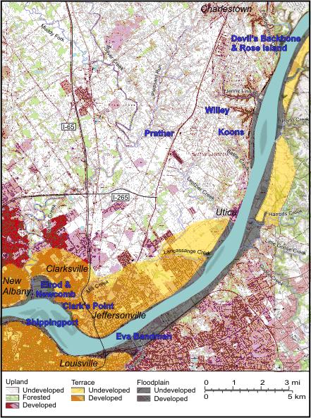
Site Location
The Prather site
is located in the greater Louisville metropolitan area in Grant 52,
between Jeffersonville and Charlestown, Indiana. It is also situated
immediately west of the former Indiana Army Ammunition Plant (INAAP),
in a once rural area that is rapidly being transformed
by residential and industrial development. In the 1940s, the
Prather family farm extended south of SR 62 and into the area developed
for the INAAP.
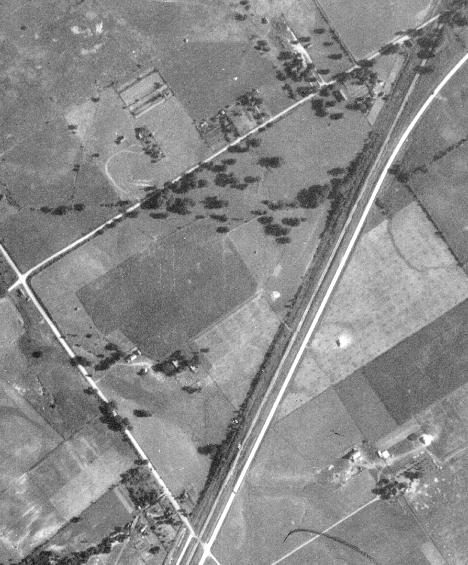
Airphoto of Prather Site area (circa 1940)
Land use in the site locale previously was row crops and pasture.
Over the decades, plowing for crops is responsible for deflating
the mounds
observed previously. Today, the site locale is used for pasture
and no-till agriculture, and the mounds – whether man-made
constructions for structures, refuse accumulations, or undulations
of the karst upland – are
suggested only by several slight elevations.
Threats
This area
is presently the subject of industrial development plans, and residential
expansion
has exploded on private lands. The planned construction of a new bridge
across the Ohio River is located near the Prather site and will increase
the scale and pace of development. Consequently, the long term preservation
of this site is threatened by multiple modern developments making our current
work all the more urgent.