 |
|
CURRENT
RESEARCH |
|
Learn
more about
Indiana Archaeology Month at Hovey Lake HERE! |
| Research
at the Hovey Lake site in 2003-2005 is supported by: a grant from
the Federal Highway Administration
(FHWA) under the Transportation Enhancement Program, Indiana
University, and private contributions. The Indiana
Department of Transportation (INDOT) administers the TE grant.
Also contributing to the research project are: Indiana Geological Survey, Indiana
University - Bloomington Department of Anthropology, the Indiana State Museum, University of Southern
Indiana, University of Evansville,
Indiana State University, and
community groups and volunteers. |
|
Last
Updated 9.6.2004
|
Hovey Lake Questions
1) How did the village develop and change over time?
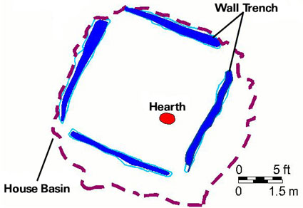
Excavated house, block 1.
Excavating and dating houses and other structures in a variety of locations across this large village to determine their is a key part of the research plan. Block 1 contained the remains of a building used for storage and a house whose burned walls collapsed into the house basin. Block 2 contains a building, possibly a house of unknown size, that had a series of five episodes of construction and reconstruction. The dates from these areas bracket a wide span from about A.D. 1400 to 1650.
The excavation in block 4 was begun in 1999 to discover additional structures, and the block 3 excavation was expanded to provide a larger sample of the structure basin fill. Radiocarbon (C-14) dates of A.D. 1275-1410 were obtained from corn kernels recovered from this fill.
2) Is the “empty” area seen in surveys and air photos indeed a central plaza?
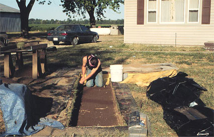
Rexford Garniewicz excavating in block 5, which is
located in the plaza area.
Historically, many Native American groups had plazas in their villages which they used for recreation, social activities, and ceremonies. Did the central area of the Hovey Lake site lack houses and storage features, or did it have special buildings?
The 1999 test excavation at block 5 was in the presumed plaza area, and the results were entirely consistent with an area that would have been used as a plaza. There were significantly fewer artifacts and features, which is what would be expected in an area of the village reserved for community events rather than for building houses or storage pits.
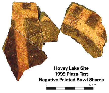
Among the few artifacts found in excavation block 5 were sherds from a negative painted pottery bowl. This type of pottery has not previously been recorded for the residential zone at the Hovey Lake site, and the design suggests a quartered circle or a cross-in-circle. Finding a rare type of ceramic vessel not found in the residential areas of the site indicates a difference in the way this part of the site was used, and is consistent with the hypothesis that this part of the site was indeed a central plaza area. In the future, additional testing in and around the plaza should be done to obtain radiocarbon dates and map the plaza limits.
3) How did the villagers make a living and what foods did they eat?
Research to date is
revealing that the people relied on a wide range of wild plants and animals,
and grew corn, beans, and squash. We are not yet able to compare this
village site with others located in different environments, because our
excavation samples are limited. Finding household refuse and well-preserved
food remains continues to be a research priority. Therefore, the archaeology
team will expand the excavation inside a house basin that was discovered
in block 4 in 1999, and explore a new section of the residential zone
in hopes of finding another structure.
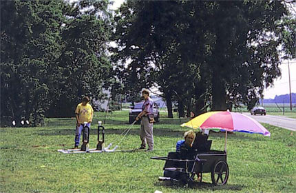
Bruce Douglas
from the Indiana University Department of Geological Sciences using
Ground Penetrating Radar with the help of Cheryl Munson and Jocelyn Turner.
They are using the instrument to survey an area near block 4.
To help select the best areas for test excavations that would meet the research goals, the IU archaeology team collected additional survey data in several tracts of the residential zone and possible plaza during spring and summer of 1999 and 2000.
This involved taking a series of soil samples by using a ¾-inch coring tool. Cores were taken along the grid lines at regular distances to assess the nature of the deposits (see photos in Scrapbook).
With the help of Bruce Douglas from the Indiana Geological Survey, the archaeologists also carried out a geophysical survey. Ground Penetrating Radar (GPR) was used to “see” what is below the ground. They first obtained images of known subsurface features in blocks 3 and 4: wall trenches, pit features, and burned house floor. The Ground Penetrating Radar was then used in a previously unstudied area of the site to look for similar patterns.
As of Fall 2003, GPR work has resumed at Hovey Lake with the intent of further addressing these and other unanswered questions at Hovey Lake.


