Bone Bank Archaeological Research
Posey County, Indiana
Rescue Excavations at the Bone Bank Archaeological Site in Southwestern Indiana
 Introduction
Indiana's First Archaeological Excavation
Survey and Testing
Significance
Project Goals
Research Stages
Expected Results
Bone Bank in 2000
Planning for 2001
Current Work
In the News
Fall 2001 Lecture
References
Geomorphological History
Links
Maps
Introduction
Indiana's First Archaeological Excavation
Survey and Testing
Significance
Project Goals
Research Stages
Expected Results
Bone Bank in 2000
Planning for 2001
Current Work
In the News
Fall 2001 Lecture
References
Geomorphological History
Links
Maps
PROJECT GOALS
Erosion at Bone Bank has continued unabated, probably since shortly after the Caborn-Welborn occupation. Now little of the site survives. There is no practical way to "hold back" the river to prevent further erosion. Therefore, rescue excavations are the only recourse to learn about this Mississippian village.
The primary goal of the Bone Bank rescue excavation project is to recover a representative sample of archaeological materials and features still preserved at the site that associated with the Mississippian Caborn-Welborn phase. Additional elements of the project involve public education, to share the results of this research with people of all ages.
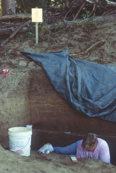
Looking south/southeast. Cheryl Munson excavating in Test Units A-F. The modern ground level is seen just below the bottom of the posted yellow Excavation Permit. It is illegal to excavate without a permit or the permission of the landowner.
The excavation sample to be recovered needs to be of sufficient size and quality to permit comparison with other Caborn-Welborn sites, and this means obtaining a large enough sample of ceramics, lithics, plant and animal remains, and radiometric dating samples. Therefore, attention will be focused on the best-preserved areas of the site, where materials and features are most abundant. Because the site is stratigraphically complex, and most of the cultural deposits are covered by recent alluvium, a two-stage project is planned.
The site is stratigraphically complex because there are three distinct areas which vary as to depositional history and cultural use (Munson 2000). These areas are: (1) the back bar swale, located on east side of the village, but exposed along the riverbank at the north end of the site; (2) the terrace deposits that make-up the ridge crest, which is exposed in the center of the site; and (3) the Cypress Slough fill deposits in the south part of the site, which cover the south slope of the terrace ridge near the shore of the former lake.
(1) Back bar swale: Surveys along the eroding bank and limited test excavations demonstrate that the cultural deposits in the back bar swale locale represent a buried midden that is covered by post-Caborn-Welborn alluviation. The alluviation resulted from massive land clearing begun in the early 1800s.
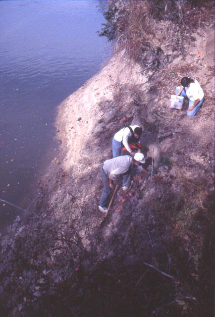
Looking north. Patrick Munson and others survey the bank for cultural materials at the north end of the site, where the back bar swale deposits intersect the riverbank. Mississippian artifacts in this location are about 2 meters below the existing ground surface.
(2) Terrace: Testing shows that Caborn-Welborn materials are confined to the plow zone, and to pit features that extend below this zone. Recent alluvial soils are also present on the low terrace, so that in places there are two plow zones or a deep, accretional plow zone. At the highest part of the terrace, cultural materials are so spare as to suggest that the terrace crest may have been scoured away by flooding, leaving only the pit features. The number of pits in the terrace deposits that have been observed along the riverbank has declined as the bank has been eroded toward the east.
(3) Cypress Slough fill: Deposits at the south end of the site contain both a buried midden on the slope above the now-filled in lake and pit features which originate within this midden. The alluvium which covers the midden on the south in the Cypress Slough fill is stratigraphically equivalent to that on the north in the back bar swale.
Surveys and testing indicated two areas of research priority. One is the 0.3-0.4 m thick buried midden at the north part of the site, in the back bar swale. To the south on the terrace deposits, the priority for excavation are the shallow deposits which may contain additional pit features, and perhaps remnants of a stockade wall. Further south, the buried midden deposits and pit features on the terrace slope immediately north of Cypress Slough should be a focus of excavation.
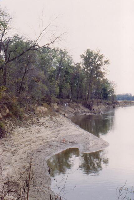
Looking south. Survey along the bank showing the terrace deposits (left) and survey team (center) at the buried midden and pit features. The bank area without trees (right) is part of the filled-in lake at Cypress Slough.
While the above synopsis suggests we have documented Bone Bank’s stratigraphy, our view has essentially been limited to one dimension, north-south, along the river bank. At the south end of the site, we still need to know to how far the buried midden deposits extend to the east and where they are most dense, in order to plan specific excavation strategies. Soil cores will be used to collect data on the types, density, and distribution of buried artifacts.
To map the buried culture-bearing zones in three dimensions, we will collect a series of solid earth soil cores to quantify cultural materials by location and depth. We will then use information about the distribution, density, and depth of cultural materials to select the best area for the South Block excavations. A similar procedure has proven effective in a number of buried archaeological contexts (Stafford 1995).
Return to Top
Last updated on 8/06/2001
Send Comments to: munsonc@indiana.edu
Site sponsored by Indiana University