Bone Bank Archaeological Research
Posey County, Indiana
Rescue Excavations at the Bone Bank Archaeological Site in Southwestern Indiana
 Introduction
Indiana's First Archaeological Excavation
Survey and Testing
Significance
Project Goals
Research Stages
Expected Results
Bone Bank in 2000
Planning for 2001
Current Work
In the News
Fall 2001 Lecture
References
Geomorphological History
Links
Maps
Introduction
Indiana's First Archaeological Excavation
Survey and Testing
Significance
Project Goals
Research Stages
Expected Results
Bone Bank in 2000
Planning for 2001
Current Work
In the News
Fall 2001 Lecture
References
Geomorphological History
Links
Maps
THE GEOMORPHOLOGY OF THE BONE BANK LOCALITY
From: "Archaeological Survey and Testing at Protohistoric Mississipian Sites in Southwestern Indiana," by Cheryl Ann Munson, June 2000
Appendix I:
The Geomorphological History of the Bone Bank Site Locality: 12,000BC to AD 2000
By Patrick J. Munson and Cheryl Ann Munson
What remains of the Bone Bank site lies on a remnant of the first (lowest) terrace of the Wabash River, at an elevation about 1.5-3.0 m (5-10 ft) above the modern floodplain (Figure I.1; also see report Figures 2 and 12). Cypress Slough, now mostly filled with alluvium, lies immediately south and east, and a bend of the Wabash is laterally eroding the western margins of the site, as it has been for at least 200 years. Presently the site has little resemblance to its appearance in 1807, when it was visited by the government land surveyor Arthur Henrie, or when it was first investigated archaeologically in 1828 by Charles Alexandre Lesueur (Bonnemains 1984; Hamy 1968) , and its physiographic characteristics even then were greatly different from those that existed when the protohistoric Caborn-Welborn phase peoples occupied this location.
The surface upon which the Bone Bank site lies was formed during the waning stage of the Pleistocene. Subsequently, the area around the site, and eventually the site itself, was repeatedly modified by the lateral movement and alternate downcutting and filling of the Wabash River. Beginning about 21,000 years ago, both the Wabash and Ohio began carrying great volumes of meltwater from the Wisconsinan glaciers, which by this time had advanced southward into their upper valleys. During the next several millennia these torrents moved large quantities of granular sediments down the valleys, forming a floodplain surface that existed many meters above the modern floodplain. The ice margin then receded from the headwaters of the Wabash and Ohio, and subsequent downcutting left this early surface as a high terrace (Thornbury, 1950; 1958;1972; Shaver 1979; Frye et al.; Fraser and Fishbangh 1986).
By 15,000 years ago another floodplain surface had stabilized, at least throughout the Wabash Valley and its southward-flowing tributaries. This surface, delineated by the 360 ft ASL (109.7 m) contour interval in the Wabash-Ohio confluence area, lies about 5 m above the modern floodplain. Subsurface sediments, informally designated as the Prairie Creek member, have been described by Autin (1996). In general, they consist of poorly sorted, upward-fining, cross-bedded or plane-bedded sand and gravel to elevations about 5 m above the normal water level of the Wabash. These granular sediments are abruptly capped by 2-3 m of slightly sandy silt. The sandy silt facies has been modified by oxidization and pedogenesis into a compacted, reddish-yellow (7.5-10 YR Munsell values) unit, which may or may not be veneered by later (Holocene) overbank (and in some cases anthropogenic) sediments.
During the last several thousand years of the Pleistocene, this surface in the vicinity of the Bone Bank location was bisected by a meandering channel of the Wabash River. That part of Levy Slough that lies north and northeast of Bone Bank (Figure I.1) lies in a meander loop of this terminal Pleistocene Wabash River channel. At that time Wabash River flowed northeastward at this location and then curved to the south and southwest to join the Ohio some 5 km east or southeast of its present mouth. The sediments that underlie the surface of the Bone Bank site(Figure 10) were deposited at this time, as the inner (latest) point bar of the then active Levy slough channel. The swale that lies immediately east and north of the remaining part of the Bone Bank site was a backbar swale of this Levy Slough meander, and Yellow Pond (Figure I.1) lies in a backbar swale of an earlier point bar. Some time prior to 10,500 BP this part of the Wabash channel was cut off upstream from Bone Bank, and the river began following a course that lay farther west, to join the Ohio somewhere between about 2 km upstream (east) to 6 km downstream (southwest) of its present mouth.
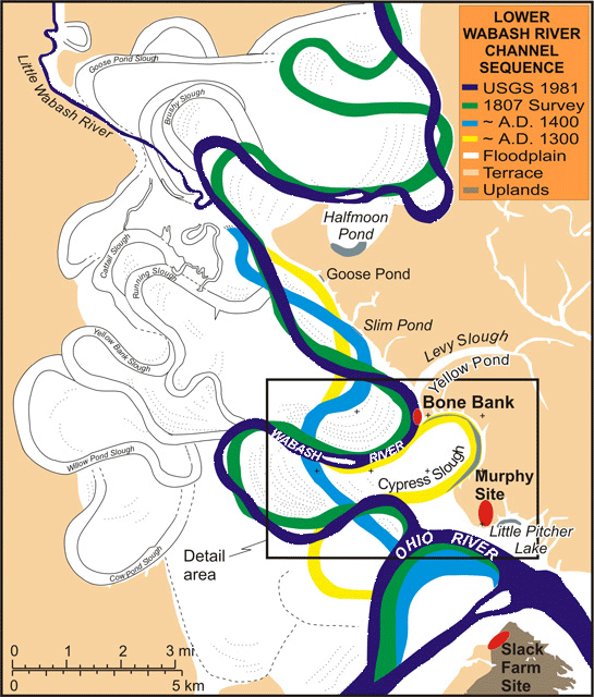
Figure I.1. Sequence of channels at the Mouth of the Wabash River and the Bone Bank locality, (U.S. Geological Survey topographic maps, Wabash Island, [1981], Emma, [1978], New Haven, [1964], and New Haven SW, [1964], 7.5 minute quadranges).
Based on several bone fragments recovered from sand and gravel beneath the archaeological deposits (report, Figure 13), the articulated, or at least semi-articulated, carcass of a Pleistocene peccary (species undetermined) was incorporated in the point bar sediments as they accumulated. Peccaries became extinct in eastern North America before 11,000 BP. After all or at least most deposition had occurred on the point bar, its sediments were rent by a small liquefaction feature (a 3 cm-wide, sand- and gravel-filled feeder dike) that resulted from a very strong earthquake that has been dated from other contexts to about 12,000 +/- 1000 BP (Munson et al. 1997). A Paleoindian Clovis projectile point, reported to have been collected from the Bone Bank site (Adams 1949:24-25), might have been lost or discarded by persons camping on the point bar of the then-active Levy Slough channel or along the lake that occupied the paleo-channel after it had been abandoned.
By 10,500 years ago, downcutting of the Wabash and Ohio rivers left the Prairie Creek member sediments perched as a low terrace, and the Early Holocene Wabash floodplain laid some 3- 4 m (350 ft ASL contour interval) below the terrace surface. This “high floodplain” (from a modern perspective) is the Black River member as defined by Autin (1996); numerous radiocarbon samples from these sediments date its formation from about 10,500 to 6500 BP (Munson and Munson 1996 : Table 4:3). The downcutting and deposition of floodplain deposits took place west of the fossil point bar/low terrace at the Bone Bank locality. Additional downcutting during the Middle Holocene lowered the floodplain still farther, but to a much lesser extent; the floodplain surface by that time was about 1 to 1.5 m lower (345 ft ASL) than the Early Holocene surface (and 5 m below the terminal Pleistocene terrace surface).
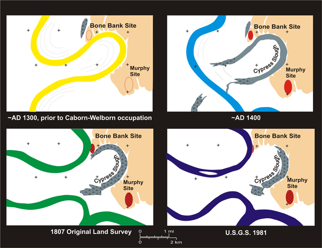
The general sequence of post-Pleistocene channel migrations of the lowermost Wabash River has been unraveled by examining historic and topographic maps, soils, and aerial photographs for scroll bar patterns and channel remnants. Known rates of channel river bend expansions in the last 200 years provide evidence about the likely dating of channel migrations during the late prehistoric and protohistoric periods. Figure I.1 illustrates the channel positions indicated for 1807 (survey by U.S. Government Land Office) and 1981 (U.S. Geological Survey), as well as our interpretation of the locations of channel positions dating pre-A.D. 1300 and ca. A.D. 1400. In addition, portions of earlier channels are shown on this map. Figure I.2 shows the location of the Bone Bank site with respect to the sequence of four channel position: pre-A.D. 1300, ca. A.D. 1400, 1807, and 1981.
Figure I.2. Changes in the environmental setting of the Bone Bank site locality over the last 1000 years, based on reconstruction of the geomorphic history.
A “spur” of terrace on the east side of the Wabash valley just downstream from the modern mouth of the Little Wabash River (Figure I.1), plus an extensive swath of Early Holocene floodplain sediments along the eastern margin some 10 km downstream from there, seems to have diverted the Wabash toward the western side of the valley during much of the Middle and Late Holocene. The extensive meanderbelt that lies 10 to 20 km west and northwest of Bone Bank shows at least four generations of migration and cut off of major river channel segments: namely, from earliest to latest, Cow Pond Slough, Willow Pond Slough, Yellowbank Slough, and Running Slough.
The attraction of the Bone Bank location to people of the Middle-Late Archaic, Early Woodland, and Middle Woodland periods (all of which are represented by evidence of apparently minor occupations at the site) was not the proximity of Cypress Slough, which did not yet exist. Nor was the attraction proximity to the Wabash River, because during much or all of the period between 6500 and perhaps 2000 years ago the river was located many kilometers to the west. Rather the attraction was the Levy Slough marsh or swamp that then extended southwestward from its present (and now greatly filled in) location to the north and west of the fossil point bar/terrace that is the Bone Bank locality. The areal extent of the pre-Mississippian occupations was probably much larger that what now remains, based on reports of site size provided by Lesueur (Bonnemains 1984; Cox 1874). Not only have the western and northern parts of the site been destroyed by eastward lateral erosion since AD 1800, but an undeterminable (probably substantial) area at the southern part of the terrace locality was undoubtedly destroyed by the pre-AD 1300 expansion of the river bend while it occupied the Cypress Slough channel.
At some point in the Late Holocene, the Wabash abandoned the Running Slough channel and breached the eastern end of the swath of higher, Early Holocene sediments that lie between the modern mouth of the Little Wabash and Bone Bank. Although the date of this event has not been determined, it was likely some time before AD 500; if Goose Pond (see Figure I.1) is a talweg remnant of the earliest of these eastern channels, then the position of the Middle Woodland site 12 Po 1181 on the margin of this channel would indicate emplacement of the eastern channels before the end of the Middle Woodland period. Whatever the relationship to the Goose Pond channel, migration of the river downstream from this location had a profound effect on the Bone Bank location. Two “gooseneck” bends began forming, one upstream from the site migrated to the west and southwest of Bone Bank, while its downstream counterpart migrated eastward to the south and southeast of the site (Figure I.2a). The downstream, eastward-expanding bend began eroding into the terrace, enlarging (or perhaps creating) the pronounced “notch” of the terrace that now exists to the southeast of Bone Bank. A swale that drains the terrace on the east side of the site created another slope, so that the Bone Bank locality took on the appearance of a ridge with slopes on the west, south and east.
The south end of the Bone Bank ridge, and any pre-Mississippian archaeological materials that might have existed in this southern part, were destroyed at this time, and the surface of the ridge on the river side (south) of the crest was probably scoured of materials during floods. The only in situ Archaic and Early-Middle Woodland materials that we have observed are from the “protected” slope north of the crest (i.e. near the base of the thick “Ap” in the vicinity of the historic pit shown on Figure 10). Further, any pre-Mississippian artifacts and residues that might have existed in the backbar swale along the eastern margin of the site would have been swept out as the swale was deepened by crevasse splay-like action during floods.
The “goosenecks” continued to migrate closer together southwest of Bone Bank, and neck cut off eventually occurred, about AD 1300 we think. Cypress Slough, as an oxbow lake, came into existence at this time. Based on our observations of geomorphological events at the Grayville, Illinois bend (cut off 1991) and Bull Island bend north of New Harmony, Indiana (cut off 1920), dramatic changes occurred very quickly following cut off. Within a decade the upstream end would have been plugged by a natural levee that rose a meter or more above normal river level, and the downstream end would have silted in to within a meter of normal river level. The portion of the lake farther from the active river would have been a stagnant sediment trap, and within this first decade following cut off, what had been a talweg probably 5 to 6 m deep would have filled with sediments to within 1 or 2 m of normal river level. Further, what had been a nearly vertical cutbank against the southern edge of what remained of the Bone Bank ridge would have slumped into the slough, carrying in the slump fire-cracked rocks and an Early Woodland projectile point that had been on the surface of the ridge; these slump deposits are the steeply dipping strata labeled Red Sandy Silt, CS/4C, and CS/4Bg on Figure 13.
As overbank and backswamp alluviation continued, and as the river near the cut off migrated to the west, the downstream end of the oxbow also became increasingly choked with silt, and the water in the lake became perched above the normal level of the river; its only connection to the river was a narrow, sloping drain in its downstream end (Figure I.2b). Sedimentation continued, although at somewhat slower rate and apparently intermittently. At some point, the lake dried up long enough for a gleyed, weakly-developed soil (CS/3Bg) to form. Nonetheless, within a century or so another 3 m of sediments were added to the bottom of Cypress Slough, creating a lake that was probably no more than a meter deep at most times (i.e. except during flood or drought conditions).
It was at this time (ca. AD 1400) that Bone Bank was chosen as a village location by a group of Caborn-Welborn phase people. Their new home was the well-drained terrace ridge that rose at least 7 m above the normal level of the Wabash River (and hence safe from all but the highest floods). This ridge, would have been at least 800 m long north-south, based on Lesueur’s estimates, and, about 400 m wide east-west, based on our reconstructions of the paleo-topography. The site area was roughly triangular and would have covered roughly 16 ha. Immediately to the south and east lay the (then) shallow lake of Cypress Slough, connected (then) by a drain to the Wabash River at the lower end of the lake. Immediately to the north and northwest was the lower (southwestern) end of Levy Slough, which by then was probably a cypress swamp. At ca. AD 1400 the eastern bank of a bend of the Wabash River was located about 1.5 km to the northwest of the site.
In the centuries or so following AD 1400, the protohistoric inhabitants of the site built structures, dug storage and roasting pits, and buried their dead on the ridge and along its slopes. And it was during this time that substantial quantities of sherds, faunal remains, and other rubbish washed and/or were thrown into the shallow water or muck on the slopes along the edges of both Cypress Slough and the back swale located along the eastern and northeastern margins of the site. During or shortly following the deposition of these residues, another gleyed, weak soil (CS/2Bg, BS/2Bg) formed at the artifact bearing strata.
Between the abandonment of the site (about AD 1600-1650 ?) and the early 19th century, another 50 cm or so of gleyed sediments accumulated over the artifacts and residues in the slough and swale. Of greater consequence, however, was the continuing southeastward migration of the Wabash River bend. At A.D. 1400 its edge laid about 1.5 km northwest of the village site. By shortly after abandonment of the site, it had migrated far enough southeastward to intersect the upper end of Cypress Slough. At that time a 3 m-deep drain eroded through the lake bottom sediments (this drain is seen in section at N700-750 on Figure 13). Artifacts eroded from the upper levels of the lake sediments were redeposited along the bottom of this drain, and by the early 19th century a 60 cm-diameter cypress tree was growing near its base.
Continued southeastward expansion of the bend eventually impacted the western side of the Bone Bank site. By 1807, when the government surveyors arrived, between one-third and one-half of the site had already eroded into the river (Figure I.2c). Still more was gone by 1828, when Lesueur (Bonnemains 1984:43) reported numerous burials eroding from the cutbank (hence the name of the site); his sketches of the eroding bank are reproduced in the report as Figures 9 and 10. By 1873, Dr. G.M. Levette estimated that one-half to two-thirds of what had been present in A.D. 1805-10 has been destroyed (Cox 1874:129-130), and in 1898 Clifford Anderson, in a letter to Warren K Moorehead, wrote that the site no longer produced many artifacts (Adams 1949:22-23).
Another 19th and 20th century impact on the site has been the greatly increased rate of alluviation that followed the widespread clearing of forests andcultivation in areas upstream. In the less than 200 years that followed a substantial Euro-American presence in Indiana and Illinois, more than 2 meters of silt have accumulated in Cypress Slough and the swale (CS/C and BS/C on Figure 10). Other unnatural impacts were the construction in the mid- to late 19th century of a farmhouse and associated outbuildings and facilities on the eastern part of the site, the construction of a boat ramp on its northeastern edge in the 1940s, and a subsequent small bulldozer cut and borrow pit into the swale and slough deposits (Figures 8 and 10).
However, it has been the continuing, unabated eastward migration of the meander bend of the Wabash that has destroyed and is destroying what remains of the Bone Bank site (Figure I.2d). As of this writing, no more than 1-2% of the former occupational area remains, and probably no more than 5 % of the former buried middens in the slough and swale deposits.
Return to Top
Last updated on 4/02/2024
Send Comments to: munsonc@indiana.edu
Site sponsored by Indiana University